Transforming Bear Creek
- John Speece
- Sep 4, 2025
- 3 min read
One reach at a time…
We’ve nearly reached a full year since the completion of our restoration project along Bear Creek in Talent. Our Bear Creek River Mile 19 project success shows how we can make a difference in urbanized watersheds. The planning for this project was intensive as we navigated infrastructure demands, greenway closures, fire restrictions, and more throughout the duration of implementation. Now, we get to sit back and watch nature take her river back.
Project engineer and drone videographer, Cascade Stream Solutions, was able to capture some of the most dynamic changes throughout the project landscape that we’ve compiled below. Check out the before & afters and learn why these restoration actions are crucial to the community, wildlife, and ecosystem at large.

One of the primary objectives this project sought to accomplish was reducing streambank erosion along the greenway. Specifically, the section of creek shown in the left photo above, was encroaching on the path, threatening the infrastructure along this transportation corridor. During the 2021-2022 winter, drone imagery displayed that high winter flows had eroded the stream bank 8 feet towards the Greenway, emphasizing the need to stabilize that section. Although rivers naturally change course over the years, this meandering stream needed a bit of redirection to move away from the Greenway while still allowing for a healthy floodplain-river complex.

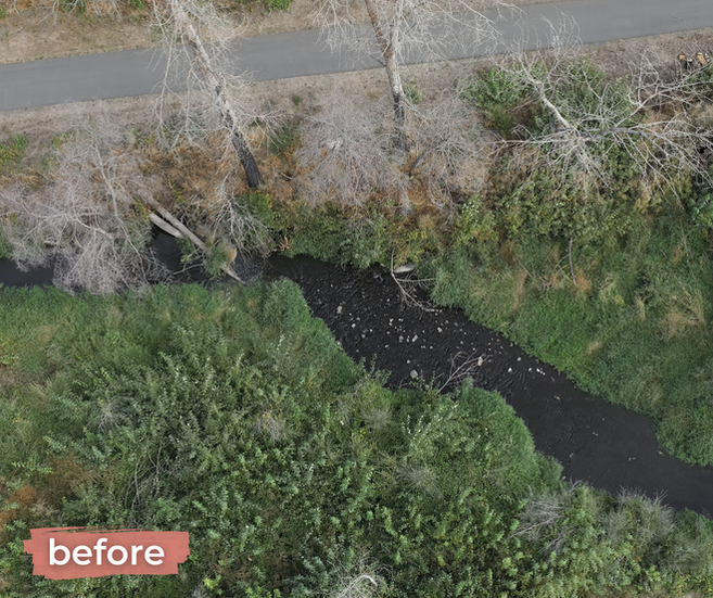


You can see in the most recent image, on the right, how the embedded log structures are absorbing the force of water that was previously eroding the bank. Some log structures are designed to move and flex during high flows; however, these structures are buried into the bank and securely pinned into place using all-thread rods. While they still function to stabilize the streambanks, their design ensures they remain stationary, significantly reducing the risk of coming loose and posing a threat to downstream infrastructure.

The next objective focused on improving floodplain connectivity. This sounds more complicated than it really is– healthy river systems spread out over the land adjacent to the channel (called the floodplain) during high flows. This allows groundwater to recharge and helps distribute the velocity and force of the water more evenly, rather than erode a certain chokepoint in the channel. Healthy floodplains have a wide range of benefits, many of which directly impact humans.


Allowing water to spread out actually mitigates flood risk. When rivers are channelized and experience a flood event, the water can spill out at high velocities and cause greater damage. The further downstream you are from a channelized stream, the more dangerous floodwaters can be. In addition to absorbing floodwaters, a connected floodplain improves water quality by allowing sediment to settle out, nutrients to be absorbed, and aquifers (drinking water!) to recharge.


Another key advantage of connected floodplains is fire resilience. Spreading out the water increases soil and vegetation moisture. This slows (or even stops) fires from spreading. The Labor Day fires in 2020 provided an unfortunate example of how this works in the opposite direction. Fueled by (invasive) blackberries and dried vegetation, the Almeda fire burned along the creek and encountered little natural resistance– amplifying the destruction for our communities.

Within the broad scope of floodplain connection, we also targeted the reconnection of historic side channels across the landscape. Side channels, also called secondary channels, are a component of a complex and resilient floodplain system. They are critical wildlife habitats– providing slower moving water for juvenile fish and spawning grounds for adults. They offer a refuge for fish during high flow events where they would otherwise be flushed down the channel, and they increase biodiversity of aquatic plants, insects, amphibians, and fish.


Drone imagery helps us illustrate the evolution of a stream over time, and we’re excited to see how Bear Creek responds to its second winter and high flow season.


You can also help contribute to monitoring of this project site by adding to our timelapses via Chronolog. Find more details and check out the timelapses on our Bear Creek RM 19 page and watch the most recent flyover below!


Comments